1.png)
Highlights
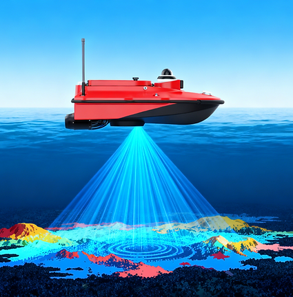
The M10 is a compact unmanned surveying vessel equipped with a single-beam echo sounder. It features a centimeter-level high-precision dual GNSS positioning and heading system, an inertial measurement system with attitude accuracy up to 0.25°, and intelligent navigation and measurement software based on the Android platform. It can autonomously navigate accurately along a preset route, collecting precise data even in complex water flow environments.
Compared to other unmanned surveying vessels in the industry, the M10 is more portable (950mm in length), has better obstacle avoidance performance (40m), a higher maximum speed (7m/s), longer endurance (6 hours on one battery with a cruise speed of 2m/s), a wider operating range (2km on 2.4GHz), and better environmental suitability (only 9cm draft).
This newly designed unmanned surveying system is the ideal choice for bathymetric surveys in lakes, inland rivers, and coastal areas.

Datasheet
Download
Main Features
Fully New Design, Improving Your Productivity

Accuracy
High-quality outcomes

Speed
Efficient runtime

Efficiency
High cost-efficiency

Intelligence
Tech-driven ease

Safety
Surveyor protection

Reliability
Damage prevention

Durability
Durable construction

Usability
Multi-mission adaptability

Hydrometry Evolution:
From Troublesome Manual Operations to Efficient Unmanned Systems



Equipped with an automotive-grade lithium battery system, delivering safe, stableand long-lasting power output for users' field work. A single battery can drive thevessel at 2m/s for 5.5 hours.
Equipped with an 850W x 2 dual propulsion system, it is more conducive to high-speedcruising in high-resistance waters such as fast-flowing and shallow waters, improving operational efficiency.
Integrated GNSS& IMU sensors deliver precise position and attitude data, comperisatingfor hull movement impact. Positioning data available via IMU even with GNSS sigrialiblocked
Features 40m max-range millimeter-wave radar, it can detects 128 obstacles simultaneously, issuestimely collision warnings, automatic obstacle avoidance. Ensures navigation safety in low visibility.Additionally, red and green navigation safety lights on hull sides reduce collision risks with other vessels.
Efficient and Accurate Operation
SPECIFICATIONS

Ultra Durable
Dual-Mode Control: Supporting both autonomous navigation for efficient large-area surveys and precise manual remote control for complex scenarios, it maximizes flexibility and saves labor.
The M10's propulsors are specially designed for water areas with heavy debris such as mine pils andinland river basins. They prevent entanglement with aquatic plants, mine slag and branches, ensuring thevessel's smooth operation.

Safety First

Meets Various Shallow Water
Operation Needs
The M10's hull is made of nano-carbon fiber polymer composite material.Iwithstands impacts from fallen trees and rocks in water, resists cracking even afterfriction in shallow areas, and maintains high durability in highly corrosive mine pitwaters
Ultra-Portable Design: Featuring a compact and lightweight hull, it requires no assembly, allowing a single operator to easily transport and deploy it for instant use.
Shallow-Water Adaptability: With a shallow draft of only 0.09m, it effortlessly navigates narrow inland waterways, shallow rivers, and coastal areas inaccessible to traditional vessels.