

Highlights
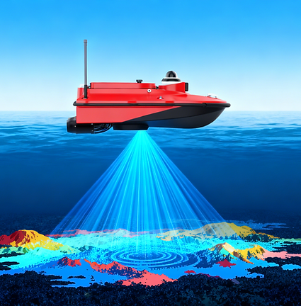
The RUIDE M10 is a compact unmanned surveying vessel equipped with a single-beam echo sounder. It features a centimeter-level high-precision dual GNSS positioning and heading system, an inertial measurement system with attitude accuracy up to 0.25°, and intelligent navigation and measurement software based on the Android platform. It can autonomously navigate accurately along a preset route, collecting precise data even in complex water flow environments.
Compared to other unmanned surveying vessels in the industry, the M10 is more portable (950mm in length), has better obstacle avoidance performance (40m), a higher maximum speed (7m/s), longer endurance (6 hours on one battery with a cruise speed of 2m/s), a wider operating range (2km on 2.4GHz), and better environmental suitability (only 9cm draft).
This newly designed unmanned surveying system is the ideal choice for bathymetric surveys in lakes, inland rivers, and coastal areas.

Main Features
Fully New Design, Improving Your Productivity

Accuracy
High-quality outcomes

Speed
Efficient runtime

Efficiency
High cost-efficiency

Intelligence
Tech-driven ease

Safety
Surveyor protection

Reliability
Damage prevention

Durability
Durable construction

Usability
Multi-mission adaptability

Hydrometry Evolution:
From Troublesome Manual Operations to Efficient Unmanned Systems


Application Scenarios
I'm a paragraph. Click here to add your own text and edit me.
Let your users get to know you.


User Case: from a Lake Dredging Project
Background:This lake is a key water resource site. its bed silt accumulation directly dictates aquatic ecological restoration effectiveness.
User Demand: Dredge 0.5m on the original riverbed with over-excavation and of -0.2~0.1m. under-excavation tolerance
Before: Manual staff gauge acceptance caused large errors with over-excavation and under-excavation values usually 0.4 1m or higher. 2) Using traditional handheld sonar: on-foot shoreline sampling, heavy workload, low efficiency. Reservoir surveys took 1–2 weeks.
Now: Integrate side - scan sonar. USV navigates autonomously via planned routes to maximize survey coverage, detects lakebed elevation, achieving dredging error of -0.08~0.02m and meeting requirements.
User Case: from a River Reach Flow Velocity Measurement Project
Background:This river reach’s flow velocity and discharge are critical for water resource regulation, flood control and ecological protection, requiring regular monitoring of cross sectional changes.
User Demand: Measure the river reach’s flow velocity and discharge every 2 hours to monitor their cross-sectional changes.
Before: Measure fixed cross-sections via bridges, or use manned boats for cross-section measurements on the river.
Now: Integrate ADCP. No fixed-location limits or manual work. Fully automatic high-precision navigation enables straighter cross-sectional lines, consistent measurements, higher data accuracy, operator safety and no human errors.


Ecological Environmental Protection Drainage Outlet Investigation Project
Background:This river reach’s flow velocity and discharge are critical for water resource regulation, flood control and ecological protection, requiring regular monitoring of cross sectional changes.
User Demand: Measure the river reach’s flow velocity and discharge every 2 hours to monitor their cross-sectional changes.
Before: Measure fixed cross-sections via bridges, or use manned boats for cross-section measurements on the river.
Now: Integrate ADCP. No fixed-location limits or manual work. Fully automatic high-precision navigation enables straighter cross-sectional lines, consistent measurements, higher data accuracy, operator safety and no human errors.
User Case: from a Freshwater Lake Water Quality Monitoring Project
Background:This lake meets residents' drinking water needs. To prevent water contamination, conduct water quality monitoring and support drinking water treatment.
User Demand: Boost water quality monitoring efficiency.
Before: Manual water sampling and monitoring via manned boats had high labor and resource costs. 2) Operations were unfeasible in complex waters, toxic environments or harsh weather, due to personnel and equipment safety.
Now: Integrated Water quality sensors. USV reaches narrow/shallow waters, expands data scope, covers more points, gathers more data for comprehensive monitoring and higher efficiency.

Product Parameters

More Users' Cases
产品亮点
This is a space to tell users about yourself and your business. Let them know who you are, what you do, and what this website is all about. Double click to start editing.
产品亮点
扩展了任务执行的安全性
1 / Item Title
Describe the item and include any relevant details. Click to edit the text.
2 / Item Title
Describe the item and include any relevant details. Click to edit the text.
3 / Item Title
Describe the item and include any relevant details. Click to edit the text.
3 / Item Title
Describe the item and include any relevant details. Click to edit the text.
扩展了任务执行的安全性
1 / Item Title
Describe the item and include any relevant details. Click to edit the text.
2 / Item Title
Describe the item and include any relevant details. Click to edit the text.
3 / Item Title
Describe the item and include any relevant details. Click to edit the text.
3 / Item Title
Describe the item and include any relevant details. Click to edit the text.

扩展了任务执行的安全性
1 / Item Title
Describe the item and include any relevant details. Click to edit the text.
2 / Item Title
Describe the item and include any relevant details. Click to edit the text.
3 / Item Title
Describe the item and include any relevant details. Click to edit the text.
3 / Item Title
Describe the item and include any relevant details. Click to edit the text.
扩展了任务执行的安全性
1 / Item Title
Describe the item and include any relevant details. Click to edit the text.
2 / Item Title
Describe the item and include any relevant details. Click to edit the text.
3 / Item Title
Describe the item and include any relevant details. Click to edit the text.
3 / Item Title
Describe the item and include any relevant details. Click to edit the text.
扩展了任务执行的安全性
1 / Item Title
Describe the item and include any relevant details. Click to edit the text.
2 / Item Title
Describe the item and include any relevant details. Click to edit the text.
3 / Item Title
Describe the item and include any relevant details. Click to edit the text.
3 / Item Title
Describe the item and include any relevant details. Click to edit the text.
扩展了任务执行的安全性
1 / Item Title
Describe the item and include any relevant details. Click to edit the text.
2 / Item Title
Describe the item and include any relevant details. Click to edit the text.
3 / Item Title
Describe the item and include any relevant details. Click to edit the text.
3 / Item Title
Describe the item and include any relevant details. Click to edit the text.